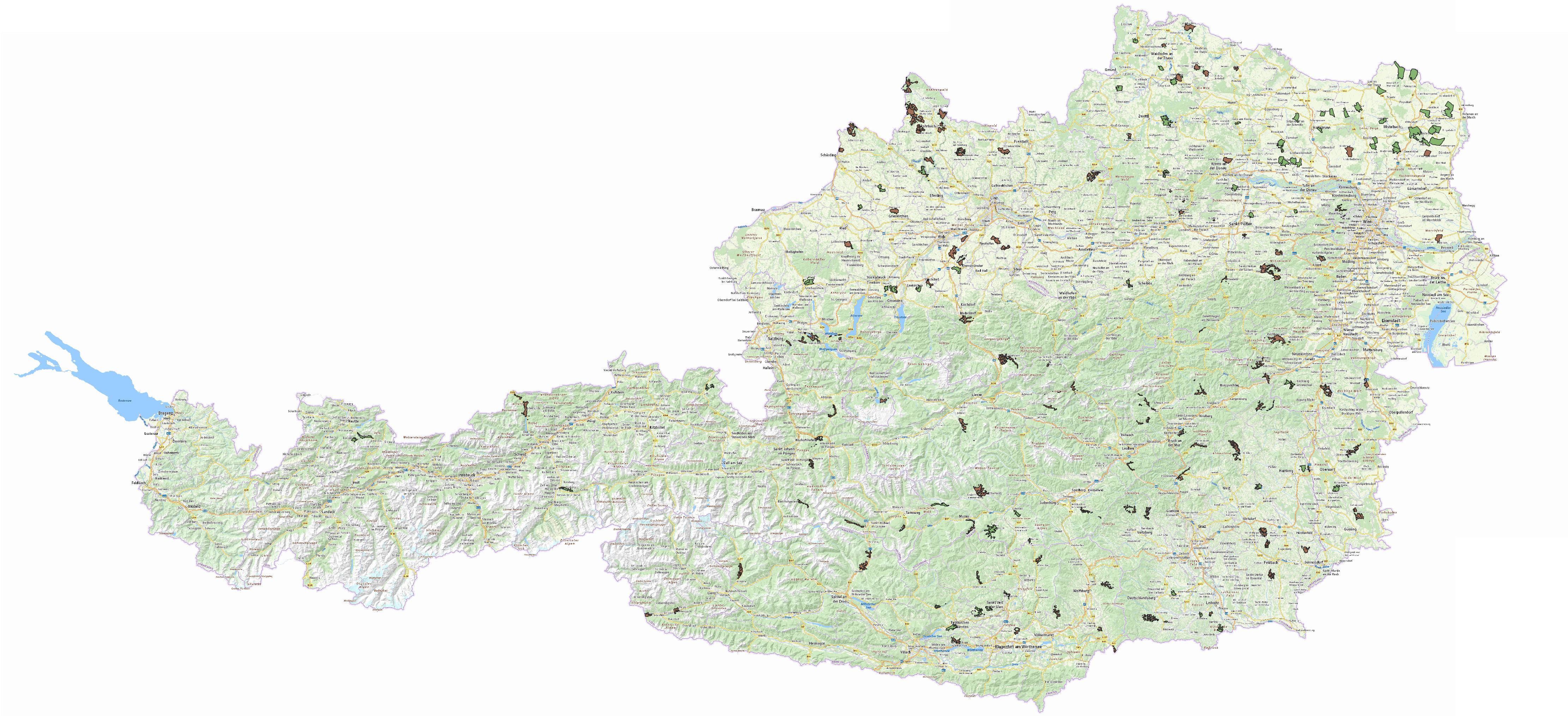
Cadastral communities as of 2022-07-25
As of July 25, 2022, A1 Telekom Austria AG and Hutchison Drei Austria GmbH were obliged to cover certain 183 cadastral communities.
Obligation A1 Telekom Austria AG
24067 Weinpolz
24162 Oberrabenthan
55114 Hüttschlag
55134 Vorderkleinarl
55302 Bairau
61145 Unterfresen
87001 Achental
12135 Stratzing
12328 Hof
46146 Pramet
47006 Kraml
47010 St. Oswald
47011 Schwarzenberg
47206 Grub
47218 St. Johann
47310 Hundbrenning
47311 Kicking
47315 Nebelberg
47321 St. Leonhard
47331 Stratberg
51207 Grassing
51214 Leombach
56005 Gappen
60010 Erhardstraße
60014 Frauenberg
60022 Hüttengraben
60033 Oberdorf-Niederdorf
60050 St. Ilgen
60210 Großveitsch
63008 Gschwendt
63013 Laas
72167 St. Martin am Techelsberg
72193 Vellach
77120 Löschental
77125 Rabenstein
77226 Obergösel
11101 Bruderndorf
19440 Fahra
19632 Würmling
19733 Laaben
34020 Goberling
34082 Unterkohlstätten
45409 Lichtenstein
56102 Fuschl
56105 Oberburgau
56521 Hinterwinkl-Ebenau
56604 Faistenau
60102 Hieflau
66171 Schönegg
67102 Bergerviertel
67305 Erlsberg
67404 Johnsbach
68022 Piregg
68024 Rettenegg
68026 Sallegg
68140 Pöllau bei Gleisdorf
73003 Eisentratten
73016 St. Nikolai
73514 Stranach
76305 Grafenbach
01707 Weidlingbach
10222 Pfaffenreith
16106 Dornbach
23002 Edlitz
23119 Klein- und Großau
23124 Kurort Semmering
23328 Puchberg am Schneeberg
45330 Ruprechtshofen
48217 Hinding
48232 Rutzenberg
63305 Eggartsberg
63323 Kainach
65213 Laßnitz-Murau
65515 Winklern
06108 Erdpreß
06220 Pframa
21010 Fistritz
21024 Ludweis
21111 Eggmanns
21196 Waldhers
33042 Oberpetersdorf
41214 Paroxedt
44012 Keneding
49116 Obermicheldorf
49401 Edlbach
49407 Rosenau
51013 Mairdorf
65025 Reisstraße
74134 Zosen
74415 Zweinitz
74521 Pfannhof
14183 Gossam
14310 Eibetsberg bei Raxendorf
19021 Laabach
19032 Saugraben
19038 Obertriesting
19318 Lilienfeld
19338 Gscheid
31037 Punitz
42016 Obertraun
42159 Theuerwang
49217 Maria Laah
58013 Mignitz
58026 Schellgaden
58035 Vordermuhr
60313 Hinterlainsach
62022 Oberlamm
62124 Kaag
62134 Maierdorf
85005 Asch mit Winkl
85202 Arnbach
Obligation Hutchison Drei Austria GmbH
09019 Obergrabern
09036 Mariathal
09037 Nappersdorf
09045 Roggendorf
09125 Radlbrunn
22028 Reinsberg
24060 Stögersbach
24220 Felles
24254 Merkengerst
24270 Richterhof
24279 Singenreith
24312 Friedersbach
24346 Mitterreith
50318 Rutzenmoos
61016 Groß St. Florian
61150 Wies
64152 Unterlungitz
64202 Freienberg
72314 Gurk
72318 Höfling
87108 Gerlosberg
12157 Höbenbach
46164 Unterwietraun
11004 Hipples
19491 Jeutendorf
34054 Oberdorf
56304 Haselreith
66026 Nestelbach
66160 Ratsch
07012 Großneusiedl
07103 Eberweis
10071 Zitternberg
13030 Kottingneusiedl
13033 Patzenthal
13042 Oberschoderlee
15002 Atzelsdorf
15023 Kettlasbrunn
15033 Olgersdorf
15035 Pellendorf
15036 Pürstendorf
15106 Drasenhofen
15110 Ginzersdorf
15114 Hausbrunn
15121 Ottenthal
20030 Mitterstockstall
20031 Oberstockstall
20034 Tiefenthal
20038 Großwiesendorf
20101 Abstetten
23015 Ofenbach
23128 Otterthal
48110 Gautzham
65224 Seebach
65309 Mühlen
65313 Puchfeld
65316 St. Lambrecht
86002 Berwang
86004 Bichlbach
06102 Windisch Baumgarten
06103 Blumenthal
06110 Gösting
06113 Großinzersdorf
21162 Nonndorf
51004 Dirnberg
57103 Au
74504 Freundsam
74516 Liemberg
74530 Sörg
40136 Utzweih
42121 Hafendorf
42126 Kirchham
45011 Haibach
The following graphic shows the cadastral communities to be covered:
The information is available in the following formats:
- Interactive mobile coverage map including cadastral communities to be covered
- List of cadastral communities to be covered as of July 25, 2022 as a PDF
- Table with cadastral communities to be covered as of July 25, 2022 in MS Excel format
- GIS representation of cadastral communities to be covered as of July 25, 2055 as Geopackage
The GIS data can be viewed using a common GIS software (for example, the free Qgis). It contais layers for the permanent settlement area as well as borders of cadastral communities.
